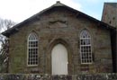
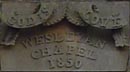
Hutton Roof Wesleyan chapel
This dates to 1850. The current St Johns Church (Paley and Austin)was built in 1881 on the site of an earlier church.
Stone Circle at Kilner Foot
There is an ancient stone circle marked as a Settlement on the OS map. It lies next to the bridleway to Sealford where it meets Gallowber Lane.
Roman Road through Hutton Roof and Newbiggin
It is thought that a Roman Road passed through the village connecting forts at Burrow and Watercrook.
Effect of the Enclosure Acts
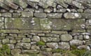
The Burton, Dalton and Holme enclosure act of 1818 resulted in much of the common land being taken into private ownership and miles of dry stone walls were built. Hutton Roof Crags and Burton Fell remain common land.
Quarries make a Boom Town
5 quarries were once extracting stone from Hutton Roof, including Red Sandstone, Yellow Sandstone and stone used around the world for grinding.
Thirlmere to Manchester Aquaduct
The Manchester Corporation Water Supply pipeline passes through Hutton Roof on its way from Thirlmere to Manchester. The Navvies stayed in the village for some time while the work was on going.
Schools
A stone dated 1773 from the original endowed school can be seen in the wall of the old school field (the triangular field at the Sealford Lane crossroads). The surviving school building is next to the church.